Built in one evening with Claude Code, a hangover, and zero plan.
Saturday evening. Hungover. The kind of state where normal people watch Netflix and eat pizza. And naturally I did those two.
I wanted a cool screensaver. A globe. Maybe some satellites on it. Something to look at while my code compiles.
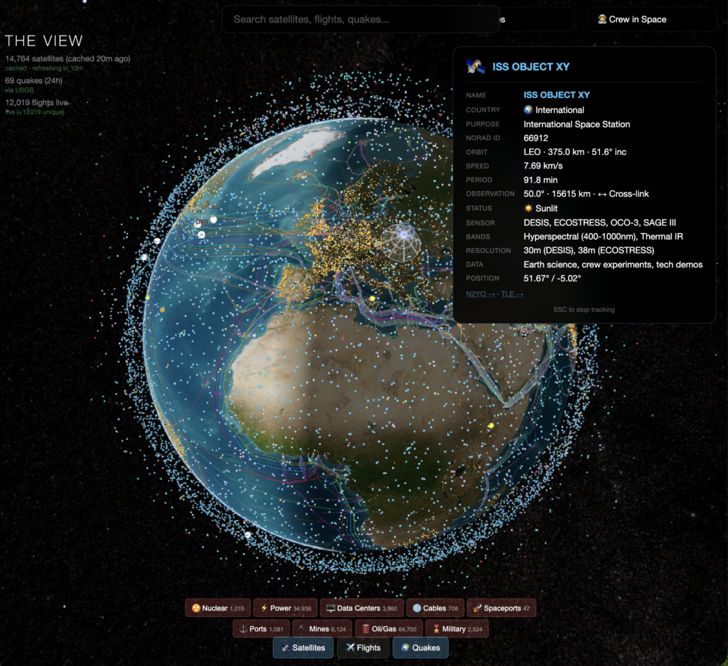
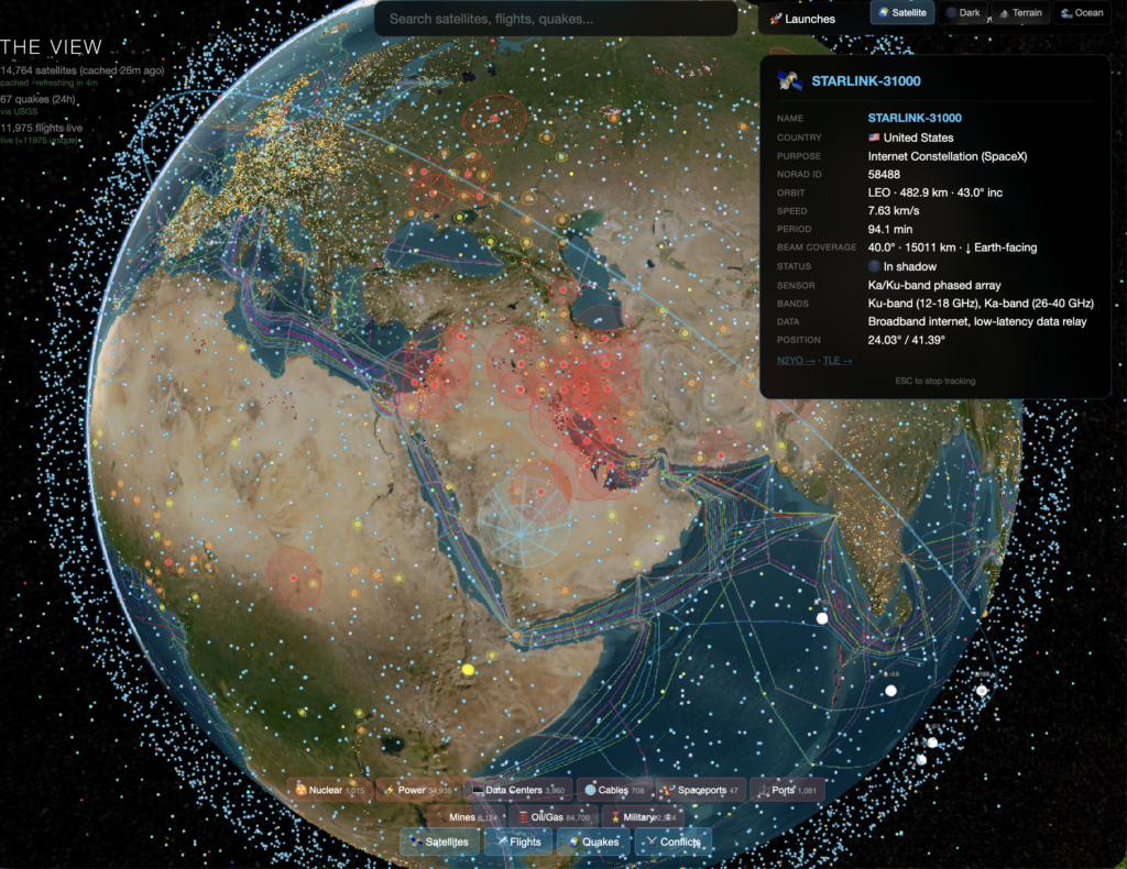
Few hours later I had 14,764 live satellites from CelesTrak, 62 real-time earthquakes from USGS, over 10k+ flights from OpenSky, a conflict heat map, subsea internet cables, nuclear sites, military bases, power grids, data centers, spaceports, ports, mines, and oil fields. All rendered on a 3D globe where I could hover over individual Starlink satellites and see their orbital altitude.
I could see the ISS passing over Europe with its crew listed in the corner like it was nothing.
How it happened:
I’ve been using Claude Code as my primary coding partner for a while now. Not “AI-assisted development” in the LinkedIn people sense. More like I describe what I want, it writes it, I break it, and we fix it together. Things move at maybe 10x the speed of solo development, and that’s a conservative estimate.
The globe started as literally one sentence. “I want a 3D globe with live satellite positions.” Twenty minutes later it worked. Then I said “add flights.” Then “add earthquakes.” Then I realized you could see the Strait of Malacca from the satellite density alone and I kind of lost my mind a little bit.
Each layer took maybe 15 to 30 minutes. Not because I’m some genius. The loop between “what if we added…” and “it’s live” is now measured in minutes, not days. The AI writes the integration, I tell it what looks wrong or what’s broken, it fixes it. The bottleneck isn’t coding anymore. It’s imagination. And honestly that shift still catches me off guard sometimes.
The moment it stopped being a screensaver
I added a topographical view and suddenly the world made sense in a way Google Maps never showed me. The Sahara isn’t a border on a map. It’s a physical wall that shaped every civilization around it. Trade routes aren’t arbitrary lines. They follow geography like water follows gravity. You can see why cities exist where they exist. Why wars happen where they happen.
When I added the conflict layer I could literally see the Iran situation bleeding red across the Gulf while tanker ships crawled through the Strait of Hormuz single-file. Subsea cables carrying Europe’s internet running straight through active war zones. “Geopolitical risk” stopped being an abstract term and became a red glow touching a purple line on my screen.
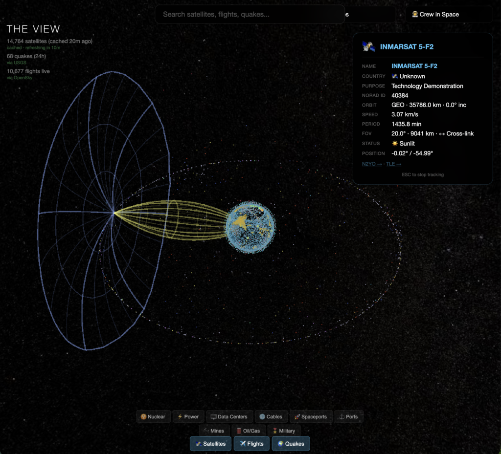
Then I added FOV projections for satellites and watched an INMARSAT in geostationary orbit project its coverage cone across half the Atlantic. One satellite, 35,000 km up, staring at the same chunk of ocean permanently. Zoom to a Starlink at 550 km and the footprint is tiny, racing across the surface. The architecture of global connectivity, visible in a way I’d never seen before.
I used to stare at my grandfather’s globe for hours as a kid. He understood all these forces through equations and theory. He just couldn’t see them rendered. This felt like building the globe he would have wanted.
What I actually built this with
CesiumJS for the 3D globe. CelesTrak for satellite TLE data. OpenSky Network for live flights. USGS for earthquake data. A bunch of static GeoJSON for infrastructure like cables and bases. ACLED for conflict data. And Claude Code for basically everything else.
No framework. No React. No TypeScript (I personally hate TS). Just HTML, JavaScript, and APIs. The whole thing runs in a browser.
What I learned
I’m not sure yet where this goes. It’s a screensaver that got out of hand. But the thing I keep coming back to is how fast it happened. One person, with an AI coding partner, hungover, in one evening, built something that would have taken a small team weeks to put together. And the only reason it exists is because I had no plan and no pressure. I just kept saying “what if we added…” and it kept working.
That’s the world we’re in now. The tools are free. The APIs are open. The AI writes the glue code. The only bottleneck is whether you have something interesting to point it at.
I’m going to add shipping routes next. Real-time AIS vessel tracking. Because I realized the globe is missing the actual movement of global trade that makes the world economy move. After that, who knows. Whatever sounds fun.